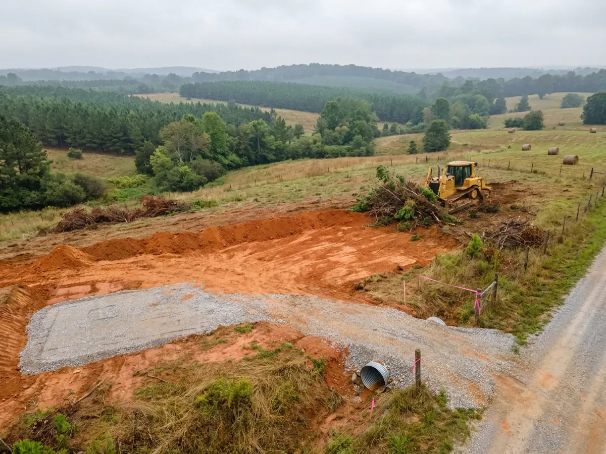
Site Preparation in South Carolina
Everything expensive that goes wrong on a barndominium goes wrong below the slab, and in South Carolina the worst of it is not a foundation problem at all. Regulation R.61-56 § 200.2 states that soils exhibiting massive or platy structure, and soils identified as having substantial amounts of expansible layer clay minerals or smectites, are unsuitable for onsite wastewater systems. That is a finding of unsuitability with no engineering fix written beside it, which means a foundation on difficult clay is a problem with a price while a parcel that will not take a drainfield may not be buildable at all. So this work starts with a survey and a soil evaluation rather than with a machine on site.
How a site preparation project runs
Four stages, in this order. The sequence matters more than it looks: getting engineering and permitting settled before anything is fabricated is what keeps a build from stalling.
Survey, then the soil evaluation that gates everything
Boundary and topographic survey, then the wastewater evaluation. Regulation R.61-56.104 requires the site to be prepared before the evaluator arrives — boundaries cleared, corners marked, and the house, well and drainfield areas staked — so the first clearing on the job is narrow and purposeful rather than general. Above the Fall Line, in the Piedmont, § 61-56.104.1 requires backhoe pits rather than borings alone.
Clearing and grubbing to the staked layout
Vegetation and stumps out, cleared material hauled or mulched, and the drainfield and its repair area protected from traffic and compaction from the first day. Counties commonly run their own land-disturbance ordinances on top of the state floor, so the county’s own ordinance is the document to read rather than the state rule.
Pad, compaction and drainage
Cut and fill to design elevation, then a compacted pad tested to spec, with swales and culverts so water leaves the building. On the mafic Piedmont this is where the soil report earns its fee — NRCS records an Iredell horizon at seventeen per cent linear extensibility sitting 23 to 74 centimetres below grade in Lancaster County, which is directly under a slab and directly under the footing line of a monolithic pour.
Well, septic and utilities
South Carolina splits the well across two regulations: R.61-44 is the permit, through a Notice of Intent under a statewide general permit, and R.61-71 is the construction standard. SCDES has forty-eight hours to review the Notice of Intent, excluding weekends and state holidays, and coverage is deemed approved if it does not respond. SCDES publishes the Notice of Intent fee as $70.00 for an individual residential well. The septic system is installed by a licensed installer, with as-built plans filed within two business days of final inspection before an Approval to Operate issues.

South Carolina names expansive clay in regulation — and it names it in the septic rules, not the foundation rules
Regulation R.61-56, Section 200.2, reads in full: "Soils exhibiting massive or platy structure, and soils which have been identified as having substantial amounts of expansible layer clay minerals or smectites, are unsuitable for onsite wastewater systems." Read where that sentence sits. It is not a foundation provision and it does not set a design requirement — it is a finding of unsuitability in the onsite wastewater regulation. On the mafic Piedmont, which is where South Carolina's shrink-swell ground actually is, the consequence is that the expensive risk on a rural parcel is more likely to be the drainfield than the slab. A foundation on difficult clay is an engineering problem with a price attached. A parcel whose soil is unsuitable for an onsite wastewater system, with no sewer available, is a parcel you may not be able to put a dwelling on at all, at any price. That is why the soil evaluation comes before the earthmoving on this building type, and ideally before the closing — and why we would rather deliver bad news about a parcel than clear it.
Where we deliver site preparation
In South Carolina the code is not what changes when you cross a city limit. § 6-9-10(A) makes enforcement mandatory for every municipality and every county, and § 6-9-30(A) puts the unincorporated area of each county under a building official too, so acreage outside town is covered rather than exempt. What changes is who reviews the drawings and what they ask for: § 6-9-50(A) leaves the adopted codes’ administrative chapter — permits, plan review, inspection sequencing, the board of appeals — out of the statewide adoption unless the local governing body adopts it by ordinance. And the wind and seismic criteria change on the Building Codes Council’s maps, whose boundaries § 6-9-105(C) requires to follow physical features rather than county lines. Two parcels twenty miles apart can carry completely different engineering.
Serving clients across the entire region.
Every locality we build in has its own reviewer, its own fee schedule and its own filled-in design criteria. The service area pages set out what each one publishes.
What actually decides the price
Square footage is the number everyone leads with, and it is rarely the one that moves a barndominium budget. These four do.
-
Whether the parcel will take a drainfield
This is the gate and everything else is a line item. Beyond §200.2's unsuitability finding, the regulation sets minimum site conditions — for a single-family system at 1,500 gallons per day or less, § 61-56.200.3 requires a minimum six inches of vertical separation between the deepest point of effluent application and the zone of saturation, which is a relative separation from the trench bottom rather than an absolute depth. Design flow itself comes from the Peak Sewage Flow Rate Standard at § 61-56.501 and is driven by bedroom count, which is why SCDES frames its own land-buying guidance as a three bedroom home versus a six bedroom home. Bedroom count drives design flow, design flow drives trench length, and trench length plus the repair area drives how much good soil the parcel has to have.
-
What the soil actually is, and where in the state you are
South Carolina's expansive ground is a north-central and western Piedmont phenomenon rather than a coastal or Sandhills one, and it is patchy rather than continuous — there is no South Carolina equivalent of a regionally mappable Blackland belt. The series that matter are Iredell, Wynott, Winnsboro, Enon, Brewback, Helena and Armenia, and the county acreages are real: Wynott covers roughly 48,170 acres in York, Winnsboro roughly 35,879 in Fairfield, Enon roughly 32,421 in Laurens, Brewback roughly 22,078 in York and Iredell roughly 21,775 in Chester. The depth band is the part that matters to a slab — NRCS records an Iredell horizon at 17 per cent linear extensibility sitting 23 to 74 centimetres below grade in Lancaster County, which is directly under a slab and directly under the footing of a monolithic pour.
-
The well, which is a different regulation and a different clock
South Carolina splits the well question across two regulations and writing that R.61-71 is the well permit regulation is wrong. R.61-44 is the permit — a statewide general permit with a Notice of Intent — and R.61-71 is the construction standard covering siting, casing, grouting, disinfection and records. § 61-44.D.1 makes it unlawful to construct an individual residential, irrigation or replacement well unless the conditions of the Department's general permit have been satisfied. There is no geographic carve-out and it is SCDES rather than the county. SCDES publishes the Notice of Intent fee as $70.00 for an individual residential well and $50.00 for an irrigation well.
-
The order the work happens in
Doing this in the wrong order is the single most expensive avoidable cost on a rural barndominium. R.61-56.104 requires the site to be prepared before the evaluator arrives — boundaries cleared, corners marked, and the house, well and drainfield areas staked — which means a specific, limited kind of clearing comes first and general clearing does not. Above the Fall Line, in the Piedmont, § 61-56.104.1 requires backhoe pits rather than borings alone, so the equipment on site at evaluation stage is different from the equipment on site at pad stage. Clearing the whole parcel and then discovering the soil is the most expensive sequence available on this building type.
Site Preparation in South Carolina: common questions
7 questions we get asked most often about building in South Carolina. If yours is not on the list, ask it directly.
What actually makes a South Carolina parcel unbuildable?
Is expansive clay a real problem in South Carolina?
Which parts of South Carolina carry the shrink-swell ground?
Do I need to worry about sinkholes?
What about liquefaction near the coast?
Who permits the well, and how long does it take?
In what order should the site work actually happen?
Sources
Every figure and legal reference on this page traces to a published document. These are those documents, with the date each was read.
- 1.S.C. Code of Regulations R.61-56, Onsite Wastewater Systems, SCDES copy at https://des.sc.gov/sites/des/files/Library/Regulations/R.61-56.pdf (application/pdf, 4,282,530 bytes, downloaded and read as extracted text 5 September 2026) — § 102 (the $150.00 per-site evaluation fee, set in the regulation itself), § 104 (the sequence, and the site preparation the evaluator requires: boundaries cleared, corners marked, and the house, well and drainfield areas staked), § 104.1 (backhoe pits rather than borings alone above the Fall Line), § 200.2 (“Soils exhibiting massive or platy structure, and soils which have been identified as having substantial amounts of expansible layer clay minerals or smectites, are unsuitable for onsite wastewater systems”), § 200.3 (six inches of vertical separation), § 200.6(1) (the five-foot setback and the prohibition on siting under a driveway or parking area) and § 501 (the Peak Sewage Flow Rate Standard).
- 2.S.C. Code of Regulations § 61-56.104, https://www.law.cornell.edu/regulations/south-carolina/R-61-56.104 ; § 61-56.200, https://www.law.cornell.edu/regulations/south-carolina/S-C-Code-SS-61-56.200 ; and § 61-56.501, https://www.law.cornell.edu/regulations/south-carolina/R-61-56.501 (all read 5 September 2026).
- 3.S.C. Department of Environmental Services, “Before You Buy Land”, https://des.sc.gov/permits-regulations/septic-tanks/homeowner-resources/you-buy-land (read 5 September 2026) — the statement that not all property is suitable for a septic system, the problem-signs checklist, and the three bedroom versus six bedroom framing of design flow.
- 4.S.C. Department of Environmental Services, “Professional Soil Classifiers”, https://des.sc.gov/permits-regulations/septic-tanks/professional-soil-classifiers (read 5 September 2026), the roster of licensed Professional Soil Classifiers is held by the Department of Labor, Licensing and Regulation rather than by SCDES, and the licensing chapter is S.C. Code Title 40, Chapter 65, https://www.scstatehouse.gov/code/t40c065.php (served text read 5 September 2026).
- 5.S.C. Code of Regulations R.61-44, the permitting regulation for individual residential wells, https://des.sc.gov/sites/des/files/Library/Regulations/R.61-44.pdf — § 61-44.D.1 (unlawful to construct an individual residential, irrigation or replacement well unless the conditions of the Department’s general permit have been satisfied), § 61-44.D.5 (the 48-hour review, excluding weekends and state holidays, and deemed approval on no response), § 61-44.C.3 (the district well inspector’s annual inspection target) and § 61-44.F.2 (no permit fee for a replacement well installed within one year). Read 5 September 2026.
- 6.S.C. Code of Regulations R.61-71, Well Standards, https://des.sc.gov/sites/des/files/Library/Regulations/R.61-71.pdf (read 5 September 2026) — the construction standard covering siting, casing, grouting, disinfection and records, which is a separate instrument from the permitting regulation above.
- 7.S.C. Department of Environmental Services, “Private Drinking Water Wells”, https://des.sc.gov/programs/bureau-water/residential-wells/private-drinking-water-wells (read 5 September 2026) — the Notice of Intent fee published as $70.00 for an individual residential well and $50.00 for an irrigation well, set by cross-reference to Regulation 61-30, https://des.sc.gov/sites/des/files/Library/Regulations/R.61-30.pdf.
- 8.USDA-NRCS Official Series Descriptions — Iredell, https://soilseries.sc.egov.usda.gov/OSD_Docs/I/IREDELL.html ; Armenia, https://soilseries.sc.egov.usda.gov/OSD_Docs/A/ARMENIA.html ; Winnsboro, https://soilseries.sc.egov.usda.gov/OSD_Docs/W/WINNSBORO.html ; Enon, https://soilseries.sc.egov.usda.gov/OSD_Docs/E/ENON.html ; Wynott, https://soilseries.sc.egov.usda.gov/OSD_Docs/W/WYNOTT.html ; Brewback, https://soilseries.sc.egov.usda.gov/OSD_Docs/B/BREWBACK.html ; and Helena, https://soilseries.sc.egov.usda.gov/OSD_Docs/H/HELENA.html (all read 5 to 6 September 2026) — the family mineralogy class of each series, the counties in which each was established, and Iredell’s clay content, consistence, slickensides and permeability.
- 9.USDA-NRCS Soil Data Access, SSURGO component-acreage, horizon-depth and linear-extensibility queries by survey area, posted to https://SDMDataAccess.sc.egov.usda.gov/Tabular/post.rest on 5 and 6 September 2026 — the county acreages quoted here, and the Iredell horizon measured at 17 per cent linear extensibility between 23 and 74 centimetres below grade in Lancaster County. Parcel-level lookups are done through the Web Soil Survey, https://websoilsurvey.nrcs.usda.gov/.
- 10.South Carolina Geological Survey and the South Carolina Emergency Management Division, General Geologic Map Series 5, “Geologic Hazards of the South Carolina Coastal Plain”, 2012, 1:600,000, https://www.dnr.sc.gov/geology/pdfs/GGMS5.pdf (application/pdf, 32,578,931 bytes, downloaded and text extracted 5 September 2026) — the two liquefaction-potential zones and the Bethera Scarp as the inland boundary of the higher one, the potentially karstic rocks area and the discrete known-sinkhole areas, and the map’s own statement that the information should not be used for land-use zoning, building-code requirements or defining insurance rate zones and is not intended to replace site-specific evaluations such as engineering analysis or design.
- 11.South Carolina Department of Natural Resources, Geological Survey, “Geologic Hazards”, https://dnr.sc.gov/geology/geologic-hazards.html (read 5 September 2026).
Keep reading
The pages that answer the next question this one raises.
Ready to put site preparation against a real plan? Start there and the rest follows.
Tell us about the land
Send the parcel ID or an address and we will come back with what can be built on it, the wind load it has to meet, and a realistic budget range. That conversation costs nothing.